
| Upper Palehouse Farm Palehouse Common Framfield |
| Historical records | |||||
| c 1825 | 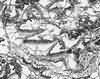 | Part of the 1 inch to 1 mile map of Sussex produced in 1825 by Christopher and John Greenwood | Palehouse Farm | ||
| 1851 | Stevenson, Spencer | Spencer Stevenson | Palehouse Farm | Post Office Directory | |
| 30th Mar 1851 | Census | Head, employs 2 people; occupation: farmer | Spencer Stevenson | Palehouse | 1851 Census Framfield, Sussex |
| Sister | Lucy Jane Stevenson | ||||
| Brother | George Stevenson | ||||
| Sister | Hannah Stevenson | ||||
| Lodger | Caroline Cottington | ||||
| 1867 | Directory entry | Broomfield James, farmer, Pale house | Pale house | Post Office Directory | |
| c 1899 | 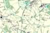 | Part of the 6 inch to 1 mile map of Sussex produced in 1899 by Ordnance Survey | Palehouse | ||
The Weald is at Database version 14.05 which has ongoing updates to the 395,000 people; 9,000 places; 613 maps; 3,308 pictures, engravings and photographs; and 248 books loaded in the previous version


