
| Woodgate Danehill Fletching |
| Historical records | |||||
| c 1795 |  | Part of the 1 inch to 1 mile map of Sussex produced in 1795 by William Gardner and Thomas Gream | Woodgate | ||
| c 1825 |  | Part of the 1 inch to 1 mile map of Sussex produced in 1825 by Christopher and John Greenwood | Woods gate | ||
| 1867 | Directory entry | Butler Philip, esq., Woodgate | Woodgate | Post Office Directory | |
| 1874 | Directory entry | Corbett Edwin Walker, Woodgate | Woodgate | Post Office Directory | |
| c 1875 | 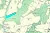 | Part of the 6 inch to 1 mile map of Sussex produced in 1875 by Ordnance Survey | Woodgate | ||
| 1888 | Directory entry | Wilson, W. H. C., Woodgate, Danehill | Woodgate, Danehill | Brooker's Guide | |
| c 1899 | 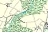 | Part of the 6 inch to 1 mile map of Sussex produced in 1899 by Ordnance Survey | Woodgate | ||
The Weald is at Database version 14.05 which has ongoing updates to the 395,000 people; 9,000 places; 613 maps; 3,308 pictures, engravings and photographs; and 248 books loaded in the previous version


