
| Hadlow |
| The Parish of Hadlow is of large extent, joining to West Peckham northward, and to the river Medway, its boundary southward; to the west it extends to the Northfrith woods and the parish of Tunbridge. It is far from being a pleasant situation, being a flat low country, much covered with large and spreading oaks, and broad hedge rows; the soil is in general a stiff clay, much of which is very swampy and wet; towards the upper part of the parish it is but poor, being very panny, and in some places inclining, to gravel; lower down it is much more fertile, and bears good corn, and is kindly for hops, of which there are many plantations, which have much increased of late years. Near the river the grass lands are very rich, and capable of fatting beasts of a large size. The rivulet called the Sheet, which flows from Plaxtool by Oxenhoath, crosses this parish, joining the river Medway, a little above Brandt bridge, near which at Hartlake bridge, at the east end of this parish, is what is here called a flowing bolt, being an ingenious contrivance to pen up the water to a certain height, by which means it is capable of being let out in dry seasons, to flow over and moisten the adjoining meadows, which is at that time of the greatest advantage to them. extract from Hasted's History of Kent published in 1798 |
| Parish & other records | Before 1500 |
1500 to 1550 |
1550 to 1600 |
1600 to 1650 |
1650 to 1700 |
1700 to 1725 |
1725 to 1750 |
1750 to 1775 |
1775 to 1800 |
1800 to 1825 |
1825 to 1850 |
1850 to 1875 |
1875 to 1900 |
1900 to 1925 |
1925 to 1950 |
1950 to 1975 |
1975 to 2000 |
After 2000 |
||
| 3123 | Births | 9 | 62 | 56 | 40 | 47 | 74 | 70 | 99 | 340 | 629 | 1150 | 543 | 4 | ||||||
| 853 | Christenings | 59 | 56 | 40 | 47 | 74 | 68 | 80 | 117 | 190 | 89 | 32 | 1 | |||||||
| 135 | Marriages | 17 | 17 | 8 | 5 | 8 | 14 | 19 | 15 | 15 | 15 | 2 | ||||||||
| 150 | Deaths | 12 | 28 | 3 | 1 | 2 | 9 | 6 | 31 | 41 | 10 | 3 | 3 | 1 | ||||||
| 160 | Burials | 15 | 33 | 3 | 1 | 9 | 6 | 31 | 43 | 12 | 2 | 3 | 1 | 1 | ||||||
| Books and other documents | |
| Published | Title, author and references |
| 1798 | The History and Topographical Survey of the County of Kent - Volume V by Edward Hasted ⇒ p. 177 |
| 1814 | An Historical, Topographical and Descriptive Account of the Weald of Kent by T. D. W. Dearn ⇒ p. 101 |
| 1839 | Directory of Kent, Surrey & Sussex ⇒ entry |
| 1840 | New Guide for Tunbridge Wells by John Colbran and edited by James Phippen ⇒ p. 336 |
| 1871 | A History of The Weald of Kent with an outline of the Early History of the County, Volume I. by Robert Furley, F.S.A. ⇒ Domesday p. 219; patronage of the Church p. 398 |
| 1874 | A History of The Weald of Kent with an outline of the History of the County to the present time, Volume II by Robert Furley, F.S.A. ⇒ p. 12; p. 14; p. 20; p. 108; p. 166; p. 222; p. 291; p. 429; p. 478; p. 710; p. 839 |
| 1882 | Kelly's Directory of Kent by E. R. Kelly, M.A., F.S.S. ⇒ entry |
| 1914 | Highways and Byways in Kent by Walter Jerrold with Illustrations by Hugh Thomson ⇒ p. 322 |
| Pictures | |||||||
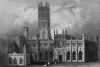 Hadlow Castle - 1830 | 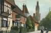 Church Street - c 1900 | 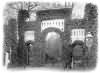 Gateway, Hadlow Castle - 1905 | 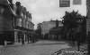 Broadway - 1926 | 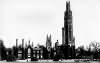 Hadlow Castle - 1939 | |||
| Places and properties in Hadlow - a directory of homes, farms, churches, schools, inns, and other places of interest that existed prior to 1900 has been compiled from Post Office directories, Kelly's directories, Trade directories, Census data, Ordnance survey maps and books of the period |
The Weald is at Database version 14.05 which has ongoing updates to the 395,000 people; 9,000 places; 613 maps; 3,308 pictures, engravings and photographs; and 248 books loaded in the previous version


