
| Pound House Framfield |
| Historical records | |||||
| c 1825 | 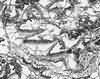 | Part of the 1 inch to 1 mile map of Sussex produced in 1825 by Christopher and John Greenwood | Pound Farm | ||
| 30th Mar 1851 | Census | Head; occupation: farm labourer | George Eade, farm labourer | Pound House | 1851 Census Framfield, Sussex |
| Wife | Jane Eade | ||||
| Son | Albert Eade | ||||
| General servant | Elizabeth Atheral | ||||
| 30th Mar 1851 | Census | Head; occupation: farm labourer | James Saunders, farm labourer | Pound House | 1851 Census Framfield, Sussex |
| Wife | Mary Saunders | ||||
| Daughter | Susanna Saunders | ||||
| Son; occupation: farm labourer | Albion Saunders | ||||
| c 1875 | 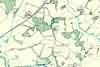 | Part of the 6 inch to 1 mile map of Sussex produced in 1875 by Ordnance Survey | Pound House | ||
| c 1899 | 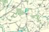 | Part of the 6 inch to 1 mile map of Sussex produced in 1899 by Ordnance Survey | Pound House | ||
The Weald is at Database version 14.05 which has ongoing updates to the 395,000 people; 9,000 places; 613 maps; 3,308 pictures, engravings and photographs; and 248 books loaded in the previous version


