
| Shoreham |
 Shoreham in 1900 |
| This parish is watered, by the river Darent, which takes its course through the middle of it. The village of Shoreham, which is by no means a small one, is situated on both sides of the river, over which there are two bridges in it, nearly, at the southern boundary of the parish, next to Otford, having both the church and the seat of New House on the eastern side of it. Hence, on both sides, the chalk hills rise, on which the soil is but barren, and much covered with flints, rise pretty high; beyond which, towards the east and western boundaries of the parish are the two small hamlets of Romney-street and Thimbling-bottom; in the fouth part of the parish, are the estates of Sepham and Filston; and, in the northern, close to the river, those of Preston and Shoreham, alias Lullingstone castle; and about three quarters of a mile westward from the former, close to the pales of Lullingstone park, though within the boundary of this parish, the farm, formerly accounted the manor of Cockhurst, belonging to Sir John Dyke. extract from Hasted's History of Kent published in 1797 |
| Parish & other records | Before 1500 |
1500 to 1550 |
1550 to 1600 |
1600 to 1650 |
1650 to 1700 |
1700 to 1725 |
1725 to 1750 |
1750 to 1775 |
1775 to 1800 |
1800 to 1825 |
1825 to 1850 |
1850 to 1875 |
1875 to 1900 |
1900 to 1925 |
1925 to 1950 |
1950 to 1975 |
1975 to 2000 |
After 2000 |
||
| 907 | Births | 4 | 6 | 7 | 97 | 219 | 370 | 194 | 10 | |||||||||||
| 88 | Christenings | 4 | 26 | 48 | 4 | 6 | ||||||||||||||
| 16 | Marriages | 6 | 2 | 3 | 1 | 1 | 1 | 2 | ||||||||||||
| 1 | Deaths | 1 | ||||||||||||||||||
| 0 | Burials | |||||||||||||||||||
| Books and other documents | |
| Published | Title, author and references |
| 1797 | The History and Topographical Survey of the County of Kent - Volume III by Edward Hasted ⇒ p. 2 |
| 1839 | Directory of Kent, Surrey & Sussex ⇒ entry |
| 1882 | Kelly's Directory of Kent by E. R. Kelly, M.A., F.S.S. ⇒ entry |
| 1909 | English Homes and Villages (Kent & Sussex) also published as Tunbridge Wells and its Neighbourhood by Lady Hope ⇒ p. 160; p. 237 |
| Pictures | |||||||
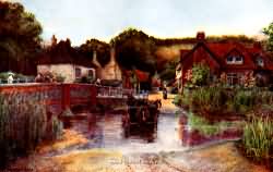
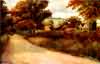 Shoreham Church - c 1900 |  Shoreham - c 1900 | 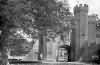 Lullingstone Castle - 1909 | 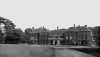 Lullingstone Castle - a Tudor house in Queen Anne dress - c 1930 | 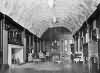 Lullingstone Castle - the state drawing room - c 1930 | |||
| Places and properties in Shoreham - a directory of homes, farms, churches, schools, inns, and other places of interest that existed prior to 1900 has been compiled from Post Office directories, Kelly's directories, Trade directories, Census data, Ordnance survey maps and books of the period |
The Weald is at Database version 14.05 which has ongoing updates to the 395,000 people; 9,000 places; 613 maps; 3,308 pictures, engravings and photographs; and 248 books loaded in the previous version


