
| Yalding |
| Yalding, antiently written Ealding, which signifies the ancient meadow or low ground. This parish lying southward of`the quarry hills is within the district of the Weald but narrow, but extends full four miles in length from north to south, the upper or northern part reaches up to the quarry hill adjoining to West Farleigh near which is Yalding down, on, which is a large kiln for the purpose of burning pit-coal into coke, which is effected by laying the coal under earth, and when set on fire quenching the cinders the method is used in making charcoal from wood, the former particularly is much used in the oasts for the drying of hops, so profitably encouraged in this neighbourhood. Below it, near the river Medway, its western boundary in this part, opposite to Nettlested, stands the seat of Sir John Gregory Shaw, bart. a retired, but not an ill chosen situation. It was for several generations the residence of the family of Kinward, which from the reign of king Henry VIII. was possessed of good estates in this parish and its neighbourhood … In this part of the parish the land is kindly both for corn and hops of which there are several plantations, and round the down there are soam rich grass lands, but further southward where the parish extends to Brenchley, Horsemonden, and Marden, it is rather a forlorn country, the land lying very low, and the soil is exceeding wet and miry; and much of it very poor, and greatly, subject to rushes, being a stiff unfertile. clay; the hedge rows are broad and interspersed with quantities of large spreading oak trees. The river Medway flows from Tunbridge along the west side of the upper part of this parish as mentioned before, there are across it here two bridges, Twyford and Brandt bridge, leading hither from Watringbury, Nettlested and East Peckham; a small stream, which comes from Marden, and is here called the Twist, flows through the lower part of this parish towards the west side of it, and joins the main river at Twyford bridge, which extends over both of them; another larger stream being a principal head of the Medway flowing from Style-bridge by Hunton clappers, separating these two parishes, joins the main river, about a quarter of a mile below Twyford bridge; on the conflux of these two larger streams the town of Yalding is, situated, having a long narrow stone bridge of communication from one part of the town to the other, on the opposite bank of the Hunton stream. Leland who lived in king Henry the VIIIth.'s reign, calls it a a praty townelet, to which however at present it has no pretension. The church and court-lodge stand at the north end of the town. A fair is held in it on Whit-Monday, and on October 15, yearly. The high road over Teston bridge, and through West Farleigh, leads through the town, and thence southward along the hamlets of Denover and Collens-street to Marden; at a final! distance from the former is the borough of Rugmarhill, esteemed to be within the ancient demesne of Aylesford, belonging to Mrs. Milner. extract from Hasted's History of Kent published in 1798 |
| Parish & other records | Before 1500 |
1500 to 1550 |
1550 to 1600 |
1600 to 1650 |
1650 to 1700 |
1700 to 1725 |
1725 to 1750 |
1750 to 1775 |
1775 to 1800 |
1800 to 1825 |
1825 to 1850 |
1850 to 1875 |
1875 to 1900 |
1900 to 1925 |
1925 to 1950 |
1950 to 1975 |
1975 to 2000 |
After 2000 |
||
| 532 | Births | 7 | 1 | 1 | 12 | 15 | 35 | 68 | 160 | 174 | 50 | 9 | ||||||||
| 126 | Christenings | 7 | 1 | 12 | 22 | 29 | 13 | 35 | 7 | |||||||||||
| 25 | Marriages | 2 | 1 | 2 | 1 | 4 | 4 | 10 | 1 | |||||||||||
| 15 | Deaths | 6 | 2 | 1 | 2 | 2 | 1 | 1 | ||||||||||||
| 14 | Burials | 5 | 2 | 1 | 2 | 3 | 1 | |||||||||||||
| Books and other documents | |
| Published | Title, author and references |
| 1798 | The History and Topographical Survey of the County of Kent - Volume V by Edward Hasted ⇒ p. 154 |
| 1814 | An Historical, Topographical and Descriptive Account of the Weald of Kent by T. D. W. Dearn ⇒ p. 273 |
| 1871 | A History of The Weald of Kent with an outline of the Early History of the County, Volume I. by Robert Furley, F.S.A. ⇒ fishery p. 163; Domesday p. 225; p. 255 |
| 1874 | A History of The Weald of Kent with an outline of the History of the County to the present time, Volume II by Robert Furley, F.S.A. ⇒ p. 130; p. 297; p. 427; p. 434; p. 587; p. 728; p. 843 |
| 1882 | Kelly's Directory of Kent by E. R. Kelly, M.A., F.S.S. ⇒ entry |
| 1914 | Highways and Byways in Kent by Walter Jerrold with Illustrations by Hugh Thomson ⇒ p. 280 |
| Pictures | |||||||
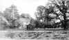 The Home - 1905 |  The Anchor Inn - 1906 |  The Medway - 1908 |  The Medway - 1918 | 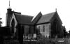 The Church - 1922 | 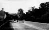 The Church - 1925 | ||
| Places and properties in Yalding - a directory of homes, farms, churches, schools, inns, and other places of interest that existed prior to 1900 has been compiled from Post Office directories, Kelly's directories, Trade directories, Census data, Ordnance survey maps and books of the period |
|
|
|
|
The Weald is at Database version 14.05 which has ongoing updates to the 395,000 people; 9,000 places; 613 maps; 3,308 pictures, engravings and photographs; and 248 books loaded in the previous version


