
| Shepherds Hill Colemans Hatch Ashdown Forest Hartfield |
| Historical records | |||||
| 1597 | Freeholder | John Farmer | Shepherds | Buckhurst Terrier | |
| John Farmer holds by deed land called Shepherds near Colman's Gate Rent 13 1/2d. | |||||
| c 1795 | 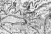 | Part of the 1 inch to 1 mile map of Sussex produced in 1795 by William Gardner and Thomas Gream | Shepherds Gate | ||
| c 1825 | 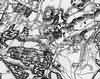 | Part of the 1 inch to 1 mile map of Sussex produced in 1825 by Christopher and John Greenwood | Shepherds Gate | ||
| 6th Jun 1841 | Census | Jesse Divall, M, Head, age 30 to 34, born Sussex; occupation: farm labourer | Jesse Divall, farm labourer | Shephards Hill | 1841 Census Hartfield, Sussex |
| Charlotte Divall, F, [Wife], age 20 to 24, born Sussex | Charlotte Divall [Diplock] | ||||
| c 1875 | 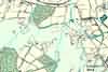 | Part of the 6 inch to 1 mile map of Sussex produced in 1875 by Ordnance Survey | Shepherds Hill | ||
| c 1899 | 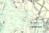 | Part of the 6 inch to 1 mile map of Sussex produced in 1899 by Ordnance Survey | Shepherd's Hill | ||
The Weald is at Database version 14.05 which has ongoing updates to the 395,000 people; 9,000 places; 613 maps; 3,308 pictures, engravings and photographs; and 248 books loaded in the previous version


