
| Historical notes about Eridge |
| 1296 | History | Eridge | Eeles' Frant | ||
| …. a list of lands left in 1296 by the 7th Earl of Hertford, which contains the earliest reference to Eridge that can be discovered. Eregge. A grange pertaining to the Manor aforesaid [Rotherfield] with 100 acres of land worth yearly 25s, 100 acres of heather and fern there worth of the year 9s 2d; also fixed rents worth 8s 9d and a water mill | |||||
| 1344 | History | Eridge | Eeles' Frant | ||
| This was the hunting park, for which the Hundred of Rotherfield had been famous for generations and which in 1344, was described as follows: A chace containing 600 acres of which the pasture is worth by the year 25s … a wood containing above 200 acres … within the said chace is a messuage called Erugge … | |||||
| 1450 | History | Eridge | Eeles' Frant | ||
| The next landmark in the history of Eridge was its inheritance in 1450 by the [Nevill] family who have continued to own it in the male line from that date until the present … | |||||
| 1573 | History | Eridge | Eeles' Frant | ||
| In 1573 Lord Burgavenny had the honour of entertaining Queen Elizabeth at Eridge Place, and her six day stay there must have caused a great stir in the neighbourhood. | |||||
| 1590 | History | Eridge | Pullein's Rotherfield | ||
Manor of Eridge with the capital mansion and park there
| |||||
| c 1604 | History | Eridge | Eeles' Frant | ||
| Shortly after Edward Nevill succeeded to the family estates, Eridge was formed into a separate Manor …. since the Lord of the Manor had taken up residence there | |||||
| 1610 | ![[North] Sussex](images/t/Speed1610E.jpg) | [North] Sussex by John Norden and augmented by John Speed | Eridge | John Speed | |
| The first engraved maps of the counties of Great Britain were the work of Christopher Saxton who, under the authority of the Privy Council, surveyed the English counties in Elizabethan times, from 1574 to 1578. In 1593 he was followed by John Norden who projected an ambitious scheme for a complete series of county histories. He published before his death a number of counties - Middlesex, Hertfordshire, Essex, Northampton, Cornwall, Sussex and Surrey. John Speed's map of Sussex is based upon Norden's map and was engraved by Jodocus Hondius. It occupies pages nine and ten of John Speed's Atlas entitled "The Theatre of the Empire of Great Britaine", is 20 1/4 inches by 15 1/4 inches in size and shows additionally an interesting plan of Chichester and a spirited representation of the Battle of Hastings. | |||||
| 1645 | ![[North] Sussex](images/t/Blaeu1645E.jpg) | [North] Sussex by Jan Blaeu | Eridge | Jan Blaeu | |
| 1695 | ![[North] Sussex](images/t/Morden1695E.jpg) | [North] Sussex by Robert Morden | Eridge | Robert Morden | |
| Robert Morden was a London bookseller from 1669 until his death in 1703. He specialised in the geographical field and was himself something of a cartographer and a publisher. Throughout the 17th and most of the 18th centuries, there was little distinction between the activity of book or print-selling and that of publishing: many booksellers were also printers or engravers. They undertook the sale of each others' work and often combined to meet the high cost of publishing a new map or reissue of an old atlas, even if the original plates were still available. This map was published in Brittania: a chorographical description of Great Britain and Ireland by William Camden. | |||||
| 1724 | History | Eridge | Eeles' Frant | ||
| William succeeded as 16th Baron in 1724 …… relinquished Eridge as the family seat having acquired Kidbrooke Park at Forest Row, and gradually the former house fell into a state of decay | |||||
| c 1724 | 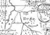 | Part of the 1 inch to 1 mile map of Sussex produced in 1724 by Richard Budgen | Eridge | ||
| 1750 | 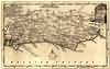 | Sussex by Thomas Kitchin | Eridge | Thomas Kitchin | |
| Thomas Kitchin, an engraver and publisher from c.1738 to 1776, held the appointment of Hydrographer to the King. His output was prolific. He engraved the maps of the British and French dominions in North America by John Mitchell (1755), which was used at the peace coucil at the end of the revolutionary war. In his later years he worked with his son (hence senior after his name in the c.1755 edition of the Small English Atlas). He died in 1784. | |||||
| 1763 | ![A New Map of [North] Sussex](images/t/Kitchin1763E.jpg) | A New Map of [North] Sussex by Thomas Kitchin | Eridge | Thomas Kitchin | |
| Thomas Kitchin, an engraver and publisher from c.1738 to 1776, held the appointment of Hydrographer to the King. His output was prolific. He engraved the maps of the British and French dominions in North America by John Mitchell (1755), which was used at the peace coucil at the end of the revolutionary war. In his later years he worked with his son (hence senior after his name in the c.1755 edition of the Small English Atlas). He died in 1784. | |||||
| 1st Sep 1787 | ![[North] Sussex](images/t/Cary1787E.jpg) | [North] Sussex by John Cary | Eridge | John Cary | |
| John Cary, apprenticed to William Palmer in 1770, went into business in 1783 as a publisher of maps, plans and road-books. He was highly successful and is referred to as the founder of the modern English School of Cartography by H.G. Fordham | |||||
| 1790 | History | Eridge | Eeles' Frant | ||
| Guns were undoubtedly cast at Eridge Furnace and in the 18th century one of these stood outside the Gun Inn at Eridge Green and … in a journal in 1790 the following account appears "(it) now lies at Eridge Green and has served for many years for the amusement of the people on a holiday or fair-day, when they collect money to buy gunpowder to threw the shell to a hill about a mile distant. The weight of the shell sinks so deep into the earth, that is costs no little pains to dig it out after each discharge, which is repeated as long as the money lasts." | |||||
| c 1795 | 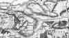 | Part of the 1 inch to 1 mile map of Sussex produced in 1795 by William Gardner and Thomas Gream | Eridge | ||
| c 1800 | History | Eridge | Eeles' Frant | ||
| Henry, the 2nd Earl, who … set on foot plans to erect a new house round the remains of the old. The architect … was James Wyatt … one of the principal creators of the revival of interest in the Gothic form of architecture. In the house he built for Lord Abergavenny he included all the features associated with that style; the towers, the battlements and the pinnacles outside and an infinity of detail in the interior decorations with more than a flavour of ecclesiastical influence. | |||||
| 1808 | ![[North] Sussex](images/t/Cole1808E.jpg) | [North] Sussex by G.Cole and engraved by J.Roper | Eridge | G. Cole | |
| The British atlas; comprising a series of county maps…intended to illustrate and accompany 'The beauties of England and Wales' published 1808. | |||||
| 31st Aug 1823 | Diary entry | Eridge | Cobbett's Rural Rides | ||
| Here I am after a most delightful ride of twenty-four miles through Frant, Lamberhurst, Goudhurst, Milkhouse-Street, Benenden, and Rolvenden. By making a great stir in rousing waiters and "boots" and maids, and by leaving behind me the name of "a - noisy, troublesome fellow," I got clear of "the Wells," and out of the contagion of its Wen-engendered inhabitants, time enough to meet the first rays of the sun, on the hill that you come up in order to get to Frant, which is a most beautiful little village at about two miles from "the Wells." Here the land belongs, I suppose, to Lord Abergavenny, who has a mansion and park here. A very pretty place, and kept, seemingly, in very nice order. I saw here what I never saw before : the bloom of the common heath we wholly overlook ; but, it is a very pretty thing; and here, when the plantations were made, and as they grew up, heath was left to grow on the sides of the roads in the plantations. The heath is not so much of a dwarf as we suppose. This is four feet high; and, being in full bloom, it makes the prettiest border that can be imagined. This place of Lord Abergavenny is, altogether, a very pretty place; and, so far from grudging him the possession of it, I should feel pleasure at seeing it in his possession, and should pray God to preserve it to him, and from the unholy and ruthless touch of the Jews and jobbers; but, I cannot forget this Lord's sinecure! | |||||
| c 1825 | 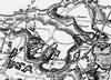 | Part of the 1 inch to 1 mile map of Sussex produced in 1825 by Christopher and John Greenwood | Eridge | ||
| 1837 | ![[North] Sussex](images/t/Moule1837E.jpg) | [North] Sussex by Thomas Moule | Eridge | Thomas Moule | |
| Thomas Moule was a bookseller. He published a number of important works on heraldry and antiquities, including Bibliotheca heraldica Brittaniae in 1822. The English Counties delineated; or, a topographical description of England has a complete series of county maps and was published by Thomas Moule in 1837 | |||||
| 1840 | ![[North] Sussex](images/t/Dugdale1840E.jpg) | [North] Sussex by Joshua Archer, Pentonville, London | Eridge | Dugdale | |
| Dugdale's England and Wales Delineated | |||||
| 1874 | Directory | Eridge | Post Office Directory | ||
| ERIDGE GREEN is an ecclesiastical parish, formed in 1856 from the civil parishes of Frant and Rotherfield; it has a station on the Tunbridge Wells, Uckfield, and Lewes branch of the London, Brighton and South Coast Railway, 1 mile south from Tunbridge Wells, near the border of Kent. ........... The area is 3,714 acres; the population in 1871 was 694. .................. | |||||
| c 1875 | 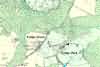 | Part of the 6 inch to 1 mile map of Sussex produced in 1875 by Ordnance Survey | Eridge | ||
| 1880 | 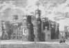 | Eridge Castle, Eridge | Pelton's Tunbridge Wells | ||
| 1882 | Directory | Eridge | Kelly's Directory | ||
| ERIDGE GREEN is an ecclesiastical parish,, formed in 1856 from the civil parishes of Frant and Rotherfield and has a station on the Tunbridge Wells, Uckfield and Lewes branch of the London, Brighton and South Coast railway, 2 1/2 miles south from Tunbridge Wells, near the border of Kent : it. is in the Eastern division of the county, hundred of Rotherfield, Ticehurst union, Tunbridge Wells county court district, Pevensey rural deanery fourth division, Lewes archdeaconry and Chichester diocese. ............ The area is 3,714 acres; the population in 1881 was 754. ........... | |||||
| 1906 | 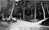 | A Drive in the Warren, Eridge | Private collection | ||
| 1907 | 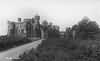 | Eridge Castle, Eridge | Eridge | Private collection | |
| 1917 | 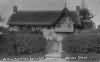 | Ye Olde Thatched Cottage, Eridge Green photographed by J. Frisby, Uckfield | Private collection | ||
The Weald is at Database version 14.05 which has ongoing updates to the 395,000 people; 9,000 places; 613 maps; 3,308 pictures, engravings and photographs; and 248 books loaded in the previous version


