
| Hole [a.k.a. Hall] Farm Buxted |
| Historical records | |||||
| c 1795 | 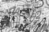 | Part of the 1 inch to 1 mile map of Sussex produced in 1795 by William Gardner and Thomas Gream | Hole Farm [Hadlow Down] | ||
| c 1825 | 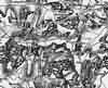 | Part of the 1 inch to 1 mile map of Sussex produced in 1825 by Christopher and John Greenwood | Hall Farm | ||
| 6th Jun 1841 | Census | Thomas Muddell, M, Head, age 40 to 44, born Sussex; occupation: servant | Thomas Muddell, servant | Hole Farm | 1841 Census Buxted, Sussex |
| Sarah Ashdown, F, age 17, born Sussex; occupation: servant | Sarah Ann Ashdown | ||||
| 6th Jun 1841 | Census | Gabriel Jarvis, M, Head, age 74, born Sussex; occupation: farmer | Gabriel Jarvis, farmer | Hole Farm | 1841 Census Buxted, Sussex |
| Rebeca Susans, F, age 35 to 39, born Sussex; occupation Servant | Rebeca Susans | ||||
| Richard Packham, M, age 20 to 24, born Sussex; occupation: servant | Richard Packham | ||||
| Jessee Bryant, M, age 20 to 24, born Sussex; occupation: servant | Jessee Bryant | ||||
| 1851 | Hemsley, John | John Hemsley, farmer | Hole Farm | Post Office Directory | |
| 30th Mar 1851 | Census | Head; occupation: farmer | John Hemsley, farmer | Hole Farm | 1851 Census Buxted, Sussex |
| Wife | Jane Hemsley [Tester] | ||||
| Daughter | Sarah Hemsley | ||||
| Daughter; occupation: scholar | Frances Jane Hemsley | ||||
| Son | John Jeal Hemsley, farmer | ||||
| Son | Jabez Hemsley | ||||
| Servant; occupation: farm labourer | William Sands | ||||
| c 1875 | 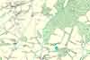 | Part of the 6 inch to 1 mile map of Sussex produced in 1875 by Ordnance Survey | Hole Farm | ||
| 3rd Apr 1881 | Census | John Daniels, M, Head, widowed, age 66, born Buxted, employs 2 men; occupation: farmer | John Daniels, farmer | Hole | 1881 Census Buxted, Sussex |
| William Daniels, M, Grandson, age 19, born Buxted | William Daniels | ||||
| Sally Daniels, F, Neice, age 29, born Buxted; occupation: housekeeper | Sally Daniels | ||||
| Jonathan Blackford, M, Servant, age 65, born Buxted, occupation: farm servant | Jonathan Blackford | ||||
| 1882 | Directory entry | Daniels John, farmer, Hole farm | Hole farm | Kelly's Directory | |
| 1888 | Directory entry | Daniels, John, farmer, Hole farm, Hadlow Down, Buxted | Hole farm, Hadlow Down, Buxted | Brooker's Guide | |
| 5th Apr 1891 | Census | William Daniels, M, Head, single, age 29, born Buxted, Sussex; occupation: game keeper | William Daniels, game keeper | Hole Farm | 1891 Census Buxted, Sussex |
| Sally Ellis Daniels, F, Housekeeper, single, age 40, born Mayfield, Sussex; occupation: housekeeper | Sally Ellis Daniels | ||||
| c 1900 | History | Hole [a.k.a. Hall] Farm | Fred Harman | ||
However in the course of time Stephen and Julie moved to Hadlow Down and there they settled to farm their own land. This farm was known as "Hole farm" and in a document I obtained from Norman Walters, Julie and Stephen's great-grandson still living at Hadlow Down. The document described the farm is as follows:- 'The house is substantially built of brick and timber, and tiled. Containing two sitting rooms, kitchen, dairy, larder etc, with five bedrooms, and attics over. The farm buildings consist of a stable with granary, and a lean-to cart shed, a timber and tiled barn with a cow shed adjoining, yard with cow-lodge stall and two pig pounds.' Stephen and Julie were to need all that room in the house for as can be seen by the family tree they had eleven children. The actual farming land consisted of 135 acres of land, consisting of arable, pasture, and shaw (shaw being a thicket of wood). In the mean time her sister Harriet and her husband John were farming at Aldebrook Crowborugh where they had two children. The photo's are of Waste farm which eventually was also farmed by the Walters boy's of Stephen and Julie. This was a smaller farm consisting of only 50 acres of land. In the photo you can see the farmhouse. The farmhouse had a sitting room, kitchen scullery, dairy, two larders, three bedrooms and an attic. The outside buildings were a barn timbered and tiled, cattle lodge, cow shed, open shed and yard, stable, harness room and wagons lodge. Again the land was same as Hole farm - arable, pasture and shaw. The farmhouse had a pleasant outlook and a elevated frontage that looked out and over to the road leading from Poundsley to Hadlow Down. In the photo can be seen the sons and a daughter posing while gathering in the harvest. | |||||
The Weald is at Database version 14.05 which has ongoing updates to the 395,000 people; 9,000 places; 613 maps; 3,308 pictures, engravings and photographs; and 248 books loaded in the previous version


